Globe Mixins
The underlying globe object is based on Cesium.
Base Globe
DANGER
This mixin is a mandatory one to build a globe activity
Make it possible to manage globe layers and extend supported layer types:
- setupGlobe(domElement, token, options) creates the underlying Cesium globe object with given Cesium Ion token and viewer options
- addLayer(options)/removeLayer(name) registers/destroys a layer based on a catalog layer descriptor
- showLayer/hideLayer(name) (un)hides the given layer in globe, on first show the layer will be lazily created
- hasLayer(name) check if a given layer is already registered
- isLayerVisible(name) check if a given layer is visible and underlying Cesium object created
- zoomToLayer(name) fits the globe view to visualize a given layer
- zoomToBounds(bounds) fits the globe view to visualize a given extent as bounds [ [south, west], [north, east] ]
- getLayerByName(name) retrieve the catalog layer descriptor for a given layer
- renameLayer(previousName, newName) rename a given layer
- removeLayer(name) destroys a given layer
- getCesiumLayerByName(name) retrieve the underlying Cesium object for a given layer
- createCesiumLayer(options) creates the underlying Cesium object based on a catalog layer descriptor, will check all registered constructor for any one matching
- registerCesiumConstructor(constructor) registers a Cesium constructor function for a given type of layer
- center(longitude, latitude, altitude, heading, pitch, roll, options) centers the globe view to visualize a given point at a given altitude with and orientation (default is pointing ground vertically [0, 0, -90]), some options like an animation
durationcan also be added- an animation
durationin seconds to perform the changes, offsetprovided relative to the base frame{ x, y, z }as an additional translation,{ heading, pitch, roll }as an additional rotation,
- an animation
- trackEntity (entityId, options)/untrackEntity() set or unset the entity that the camera is currently tracking with the following options:
modeas the mode of tracking, between theses two optionsfollowOrientation: camera will track the target entity orientation, preventing the user from moving the camerafreeLook: the user can freely move the camera around the target entity
resetHeadingattrueto make the camera face north when switching tofreeLookmodedurationas the duration of the animation when switching modeeasingas an objet with{ function: 'cubicBezier', parameters: [] }(see animate option ofcentermethod in map mixins)distanceas the distance from entity,offset{ x, y, z }as an additional translation,{ heading, pitch }as an additional rotation,
- getCenter() get the current globe view center as
longitude,latitudeandaltitude(note that the projected position on the ground is the one of the camera, it only matches the 2D version with orientation [0, 0, -90]) - getCamera() get the current globe view camera settings as
longitude,latitudeandaltitudefor position andheading,pitchandrollfor orientation - getBounds() get the current map view bounds as
[ [south, west], [north, east] ]
This mixin also adds the following internal data properties:
- layers available layers as catalog layer descriptors
Scene post processing
Post processing can be enabled on the globe, you can use the following methods to control this feature:
- setupPostProcess(postProcessName, options) handles setup of 3d post process on the scene
- selectFeaturesForPostProcess(postProcessName, layerName, featureIdList) can be used for post process that requires selected features to operate
:: tip Inputs for layers and features can also be provided as arrays to selectFeaturesForPostProcess in order to select features coming from multiple layers :::
We currently only support desaturate post process. The options parameter in setupPostProcess only expects an enabled: true|false field. This post process requires selected feature to operate, it'll desaturate the whole scene, except features that are selected.
Globe Style
Globe partly supports KDK style specification as detailled for map: color, width, opacity, maki icons as shape by relying on the pin builder. It also provides additionnal capabilities specific to 3D entities defined in layers or features as an entityStyle property.
TIP
All style properties can be templated using lodash string templates. Their final values will be computed at creation/update time.
Make it possible to setup Cesium entities objects with style based on (Geo)Json (feature) properties stored in entities:
- convertFromSimpleStyleSpec(style) helper function to convert from simple style spec options to Cesium style options
- convertToCesiumObjects(style) helper function to convert from JSON description to Cesium objects
Use register/unregisterStyle(type, generator) to (un)register a function generating a Cesium object depending on the given type:
entityStyle=> f(entity, options) returns a Cesium entity style objectclusterStyle=> f(entities, cluster, options) returns a Cesium cluster style object
The mixin automatically registers defaults styling:
entityStyle=> will create a style based on the following options merged with the following order of precedence- simple style spec options set on feature.style or feature.properties
- Cesium entity style options set on the entityStyle property in the layer descriptor
- Cesium entity style options set on the entityStyle property in the feature
clusterStyle=> will create a style based on the following options merged with the following order of precedence- Cesium cluster style options set on the clusterStyle property in the layer descriptor
- Cesium cluster style options set on the clusterStyle property in the feature
Cesium styles often rely on dynamically created objects while the input styling configuration is a static JSON. As a consequence the following rules are used to convert from JSON to Cesium objects:
- constants are expressed as strings starting with
'Cesium.' - object instances are expressed as a
{ type, options }object where type is a string starting with'Cesium.'followed by the class name like'Cesium.CheckerboardMaterialProperty', options are constructor options for the object instance The following Cesium code:
ellipse.material = new Cesium.CheckerboardMaterialProperty({
  evenColor : Cesium.Color.WHITE,
  oddColor : Cesium.Color.BLACK,
  repeat : new Cesium.Cartesian2(4, 4)
})
will result in the following Json configuration:
ellipse: {
  material: {
    type: 'Cesium.CheckerboardMaterialProperty',
    options: {
      evenColor: 'Cesium.Color.WHITE',
      oddColor: 'Cesium.Color.BLACK',
      repeat: {
        type: 'Cesium.Cartesian2',
        options: [4, 4]
    }
  }
}
Example
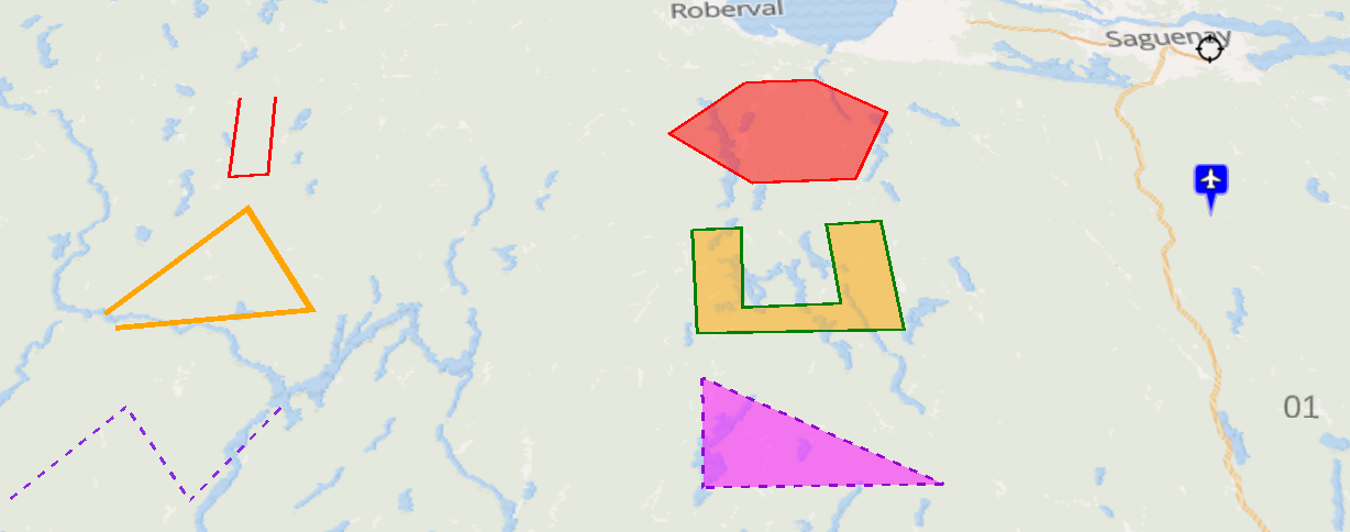
The following collection is rendered as illustrated below:
{
  "type": "FeatureCollection",
  "crs": { "type": "name", "properties": { "name": "urn:ogc:def:crs:OGC:1.3:CRS84" } },
  "features": [
    {
      "type": "Feature",
      "style": { "color": "magenta", "opacity": 0.5, "width": 3 },
      "properties": { "name": "Parc de la Colline",
        "entityStyle": { "polyline": { "material": { "type": "Cesium.PolylineDashMaterialProperty", "options": { "dashPattern": 255, "color": "Cesium.Color.DARKVIOLET" }  } } } },
      "geometry": { "type": "Polygon", "coordinates": [ [ [ -72.357206347890767, 47.72858763003908 ], [ -71.86027854004486, 47.527648291638172 ], [ -72.37075892446839, 47.539848426151735 ], [ -72.357206347890767, 47.72858763003908 ] ] ] }
    },
    {
      "type": "Feature",
      "properties": { "name": "Centre Paul-Étienne Simard", "fill-color": "orange", "stroke-color": "green", "stroke-width": 3 },
      "geometry": { "type": "Polygon", "coordinates": [ [ [ -72.357206347890767, 48.013440900213297 ], [ -72.239750684218109, 48.013440900213297 ], [ -72.253303260795718, 47.856056000888501 ], [ -72.027426984502114, 47.856056000888501 ], [ -72.036462035553868, 48.013440900213297 ], [ -71.905453795303586, 48.01646283861713 ], [ -71.891901218725963, 47.801464984333364 ], [ -72.361723873416651, 47.810567474765456 ], [ -72.357206347890767, 48.013440900213297 ] ] ] }
    },
    {
      "type": "Feature",
      "properties": { "name": "Loisirs Rivière du Moulin" },
      "geometry": { "type": "Polygon", "coordinates": [ [ [ -72.194575428959382, 48.33278115872843 ], [ -72.018391933450374, 48.33278115872843 ], [ -71.846725963467236, 48.251628525276693 ], [ -71.950629050562299, 48.107038644740094 ], [ -72.203610480011122, 48.107038644740094 ], [ -72.397864077623623, 48.221539261269051 ], [ -72.194575428959382, 48.33278115872843 ] ] ] }
    },
    {
      "type": "Feature",
      "style": { "opacity": 0.5, "width": 3 },
      "properties": { "name": "Saint-Remy-en-Bouzemont-Saint-Genest-et-Isson",
        "entityStyle": { "polyline": { "material": { "type": "Cesium.PolylineDashMaterialProperty", "options": { "dashPattern": 255, "color": "Cesium.Color.BLUEVIOLET" }  } } } },
      "geometry": { "type": "LineString", "coordinates": [ [ -73.839785615317746, 47.564240180362376 ], [ -73.627461915601779, 47.716431476953346 ], [ -73.455795945618627, 47.552045722357249 ], [ -73.279612450109633, 47.710352336655504 ] ] }
    },
    {
      "type": "Feature",
      "properties": { "name": "Sainte-Geneviève", "stroke-color": "orange", "stroke-width": 6 },
      "geometry": { "type": "LineString", "coordinates": [ [ -73.716981531178234, 47.889388912080449 ], [ -73.423342371996569, 48.091953743979651 ], [ -73.242641350961676, 47.883329977544491 ], [ -73.685358852497131, 47.862118125007399 ] ] }
    },
    {
      "type": "Feature",
      "properties": { "name": "Saint-Anicet" },
      "geometry": { "type": "LineString", "coordinates": [ [ -73.485142395986983, 48.338787334581873 ], [ -73.480624870461128, 48.161307640513321 ], [ -73.385756834417805, 48.164320903012829 ], [ -73.394791885469544, 48.338787334581873 ] ] }
    },
    {
      "type": "Feature",
      "style": { "color": "black", "text": { "label": "01", "size": "36" } },
      "properties": { "name": "Sydenham" },
      "geometry": { "type": "Point", "coordinates": [ -71.051641470913779, 47.610352336655504 ] }
    },
    { "type": "Feature",
      "style": { "shape": "airport", "color": "blue", "radius": 16 },
      "properties": { "name": "Saint-Luc" },
      "geometry": { "type": "Point", "coordinates": [ -71.110369302750115, 47.998430466372736 ] }
    },
    {
      "type": "Feature",
      "style": { "color": "transparent", "radius": 24, "icon": { "url": "kdk/position-cursor.png" } },
      "properties": { "name": "Loisirs du Fjord du Saguenay" },
      "geometry": { "type": "Point", "coordinates": [ -70.988396113551573, 48.32977780546792 ] }
    }
  ]
}
Globe Popup
Make it possible to generate Cesium labels as popups based on GeoJson feature properties stored in entities. Use register/unregisterStyle(popup, generator) to (un)register a function f(entity, options) returning a Cesium entity style object
The mixin automatically registers a default generator that will create a popup displaying a property name/value table based on the following options with the following order of precedence
- popup: set on entity.properties or layer descriptor or in the popup property of component options
- pick: array of property names to appear in the popup
- omit: array of property names not to appear in the popup
- template: Lodash template to generate popup content with
feature, itspropertiesand translation function$tas context - html: HTML content of the popup, if provided will override default display
- options: Cesium label options
TIP
If you want to disable a default popup configuration like popup: { } (i.e. display all properties) on a per-layer basis you have to explicitely unset it on your layer options using popup: null or popup: false.
Globe Tooltip
Make it possible to generate Cesium labels as tooltips based on GeoJson feature properties stored in entities. Use register/unregisterStyle(tooltip, generator) to (un)register a function f(entity, options) returning a Cesium entity style object
The mixin automatically registers a default generator that will create a tooltip based on the following options with the following order of precedence
- tooltip: set on entity.properties or layer descriptor or in the tooltip property of component options
- property: property name to appear in the tooltip
- template: Lodash template to generate tooltip content with
feature, itspropertiesand translation function$tas context - html: HTML content of the tooltip, if provided will override default display
- options: Cesium label options
TIP
If you want to disable a default tooltip configuration like tooltip: { property: 'name' } (i.e. display all properties) on a per-layer basis you have to explicitely unset it on your layer options using tooltip: null or tooltip: false.
GeoJson Layer
Make it possible to manage and style raw or time-based GeoJson map layers:
- createCesiumGeoJsonLayer(options) automatically registered GeoJson Cesium layer constructor
- updateLayer(name, geoJson, options) update underlying GeoJson data of a given layer, options like the following can also be added:
removeMissingwhentrueit will remove given features from the layer, otherwise it will add new ones found and update matching ones based on thefeatureIdproperty of the layer definitionremovewhentrueit will remove given features from the layer based on thefeatureIdproperty of the layer definition
DANGER
The style mixin is mandatory when using this mixin. If you'd like to support popups/tooltips you should also use the popup mixin and/or tooltip mixin.
TIP
Marker cluster options are to be provided in the cluster property of the Cesium layer options
The following configuration illustrates a GeoJson marker cluster layer using options set on the layer descriptor (see image below):
{
  name: 'Layer',
  description: 'My sites',
  tags: [ 'business' ],
  icon: 'star',
  attribution: '(c) My company',
  type: 'OverlayLayer',
  cesium: {
    type: 'geoJson',
    source: 'https://s3.eu-central-1.amazonaws.com/kargo/nuclear-sites.json',
    cluster: {
      pixelRange: 50
    },
    'marker-symbol': 'star',
    'marker-color': '#FFA500'
  }
}
Additional feature types
The following options can be set as feature properties to manage more geometry types:
- wall boolean set to
trueon aLineStringwill result in an additional WallGraphics, which uses the styling options of the feature - corridor boolean set to
trueon aLineStringwill result in a CorridorGraphics instead, which uses the styling options of the feature - geodesic boolean set to
trueon aPointwill result in a great circle represented as a EllipseGraphics, which radius must be specified in meters and uses the styling options of the feature - icon-text string set on a
Pointwill result in a LabelGraphics instead of a BillboardGraphics, which uses the styling options of the feature
There are a few additional specific geometry types that can be instanciated for features. When using these, they replace the 3d object used to display the feature in the scene, you can't use them in addition to some other geometries. You can instanciate:
- an animated wall using the following properties:
feature.properties.entityStyle = {
    wall: {
        minimumHeights: 200,            // height (altitude) for lowest edge of wall, can be an array if per point altitude is required
        maximumHeights: 250,            // height (altitude) for highest edge of wall, can be an array if per point altitude is required
        animateMaterialAlongPath: true, // true to trigger material animation along wall geometry
        material: {
            image: '/iframe/arrow-green.png', // source for animated texture
            animationSpeed: 50,               // animation speed, in ‘units of scene’ per second
            scale: 2,                         // texture scale factor (default to 1), can be an array to specify x and y scale factors
                                              // if both factors are equal, texture aspect ratio is maintained on the geometry
            reverseAnimation: true,           // true to reverse animation (default false)
                                              // animation flows by default from first point of geometry to last
            translucent: true,                // set to true if the geometry with this material is expected to appear translucent
            useAsDiffuse: false               // set to true to use texture as diffuse color, will be emissive otherwise (default false)
        }
    }
}- an animated corridor using the following properties:
feature.properties.entityStyle = {
    corridor: {
        width: 200,                     // width, in units of scene, of the corridor
        height: 250,                    // height (altitude) for the corridor
        animateMaterialAlongPath: true, // true to trigger material animation along wall geometry
        material: {
            image: '/iframe/arrow-green.png', // source for animated texture
            animationSpeed: 50,               // animation speed, in ‘units of scene’ per second
            scale: 2,                         // texture scale factor (default to 1), can be an array to specify x and y scale factors
                                              // if both factors are equal, texture aspect ratio is maintained on the geometry
            reverseAnimation: true,           // true to reverse animation (default false)
                                              // animation flows by default from first point of geometry to last
            translucent: true,                // set to true if the geometry with this material is expected to appear translucent
            useAsDiffuse: false               // set to true to use texture as diffuse color, will be emissive otherwise (default false)
        }
    }
}
NOTE
The animateMaterialAlongPath property in the wall (or corridor) object will create a custom wall (or corridor) object, don’t expect it to behave like a regular CesiumJS WallGraphics (or CorridorGraphics) object.
Dynamic styling
The same than for dynamic map style applies for globe. Note however that templating will be applied once the 3D entities have been created, which means that you cannot use templating on simple style spec options but rather on Cesium object options set on the entityStyle layer option.
For instance you can change the marker color or image based on a given features's property like this:
entityStyle: {
  billboard: {
    image: `<% if (properties.visibility < 75) { %>/statics/windyblack.png<% }
              else if (properties.visibility < 300) { %>/statics/windyred.png<% }
              else if (properties.visibility < 1500) { %>/statics/windyorange.png<% }
              else if (properties.visibility < 3000) { %>/statics/windyyellow.png<% }
              else { %>/statics/windygreen.png<% } %>`,
    color: `Cesium.Color.<% if (properties.visibility < 75) { %>BLACK<% }
              else if (properties.visibility < 300) { %>ORANGERED<% }
              else if (properties.visibility < 1500) { %>GOLD<% }
              else if (properties.visibility < 3000) { %>YELLOW<% }
              else { %>LIMEGREEN<% } %>"/>`
  },
  template: ['billboard.image', 'billboard.color']
}
You can also draw a path with a different styling on each part like this:
{
  type: 'FeatureCollection',
  features: [{
    type: 'Feature',
    properties: { stroke: '#000000', weight: 1 },
    geometry: { type: 'LineString', coordinates: [...] }
  }, {
    type: 'Feature',
    properties: { stroke: '#FF00FF', weight: 3 },
    geometry: { type: 'LineString', coordinates: [...] }
  }]
}
File Layer
Make it possible to drag'n'drop GeoJson or KML file on the globe. It will automatically create a new GeoJson layer named after the filename on drop. As a consequence it has to be used with the GeoJson layer mixin and will use the configured styling.
Globe Activity
Make it easier to create 3D mapping activities:
- initializeGlobe(token) setup the render engine with given Cesium ion access token, should be called first before any other method
- finalizeGlobe() destroy the render engine
DANGER
It assumes that the DOM element used by the render engine has a ref named globe